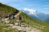
If you are looking for spectacular terrain, perhaps the best way to enjoy Aspen’s beautiful scenery is to go hiking. With over three-fourths of the Aspen district comprised of wilderness area, there are hundreds of great hiking trails that explore the mountains, valleys, lakes and rivers of Summit County.
From picnic areas to high-altitude excursions, the trails offered for hiking in Aspen seem endless. Multiple valleys and mountain peaks give hikers plenty of choices. Popular destinations such as the Maroon Bells, Castle Creek Valley, and Snowmass will provide more than enough trails and space for your adventure.
Hike to a picnic on a peak and return in time for a night on the town. Or, plan several days for a backpacking trip through Aspen’s rugged wilderness. Below you will find a list of trails, or visit the National Forest website for more information.
www.allaspen.com - Aspen trail information
AspenChamber.com hiking trails
www.trails.com - Aspen Backpacking
Brush Creek / Government Trail (easy but long)The trail begins a short distance up Maroon Creek Road at Islen Park behind the tennis courts. It continues across the river to Buttermilk Mountain. This is a pleasant hike, after a steep beginning. Hikers must be careful to stay on the trail as it crosses private property. Miles one way: 6.8 Elevation: 9,400 – 11,400 ft. |
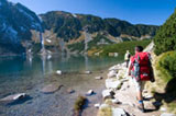
Maroon Lake Scenic Trail (easy)The trail follows the lake to the far side and meanders along the creek that flows into the lake. This is a great place for pictures and picnics. Miles one way: 1.3 Elevation: 9,500 – 10,000 ft. |
Crater Lake (moderate)The trail begins at Maroon Lake, 10 miles up Maroon Creek Road. The left trail or scenic trail follows a river and crosses two bridges, then climbs steeply to meet with the Maroon-Snowmass Trail. Distance to the trail is 1.75 miles one way. |
Conundrum Hot Springs (easy – moderate)The natural hot springs is at the end of a gently rising 8.8 miles. Camping around the hot springs is limited. If you are continuing up Triangle Pass, you can connect with the East Maroon and Copper Passes, or continue about 10 miles further to Gothic at Crested Butte. Miles one way: 8.5. Elevation: 8,500 – 12,500 ft. |
New York Trail (difficult)A topographical map is mandatory for this trail, as it is easy to get lost. Miles one way: 4.2. Elevation: 10,000 – 12,300 ft. |
Grottos (easy)This is a popular area for picnicking and exploring. There is a waterfall, some interesting rock formations, an ice cave, and numerous short trails. This is a great area for families. |
Discovery Trail (easy)This trail is located approximately 13.5 miles east of Aspen on Hwy 82, on your right. It is designed to give the blind hiker a feel for the outdoors. 22 messages are provided along the trail in both braille and in print. Nylon cord guides are provided for the blind. Self-guided tapes are available for free use at the Aspen District Forest Service Office. The hike begins at a height of about 10,400 feet. |
Sunnyside Trail (moderate – difficult)The first part of the trail contains a series of switchbacks through sagebrush and scrub oak. About 1 mile along the trail, you will cross a driveway and then continue on to Red Mountain. The trail finally joins with the Hunter Creek Trail in the Hunter Creek Valley. As there are many spurs that can lead to one getting lost, a topographical map is recommended. Miles one way: 6.3. Elevation: 8,000 – 10,000 ft. |
Rio Grande Trail (easy)This is both a hiking and biking trail. The trail starts behind the post office on Puppy Smith Road. The first two miles of the trail are paved. It then becomes a dirt trail after crossing Cemetery Road. Elevation: 7,700 – 7,900 ft. |
Ute Trail (more difficult)The trail starts close to town on Ute Avenue. The sign for the trail is approximately 0.4 miles up Ute Avenue on the right if you are headed east. It is steady uphill with switchbacks, 0.9 miles, and 1,000 vertical feet to a rock outcropping. The view of Aspen from the rock outcropping is spectacular. |
Grizzley Lake (moderate)The hike has an elevation gain of 2,000 feet. This is a moderate hike until the end, where you have .25 mile of switchbacks. Miles one way: 3.6. Elevation: 10,300 – 12,300 ft. |
East Snowmass Creek / Willow Lake (difficult)This trail is fairly steep as it goes through varying terrain along East Snowmass Creek. There is an elevation gain of 4,200 feet. Miles one way: 8.2. Elevation: 8,400 – 12,600 ft. |